Overview
New York, NY – Oct 29, 2026 The global Seismic Survey Market is gaining importance as energy companies, geological researchers, and offshore developers require accurate information about underground rock formations. Seismic surveys use controlled sound waves and specialised sensors to map subsurface structures and assess potential oil and natural gas resources. They also support geological exploration, mineral assessment, geothermal development, and carbon storage projects.
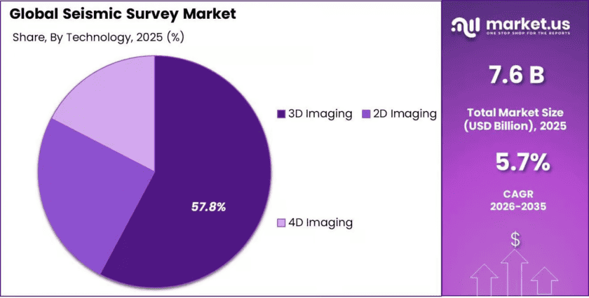
According to the supplied Market.us report, the market was valued at USD 7.6 billion in 2025 and is projected to reach USD 13.3 billion by 2035, growing at a compound annual growth rate (CAGR) of 5.7% from 2026 to 2035.
In 2025, North America accounted for 35.21% of the market, representing USD 2.6 billion in revenue. Data acquisition held a 54.83% share, geological exploration accounted for 46.89%, and 3D imaging led the technology segment with 57.80%. These segments reflect the importance of collecting reliable field data, understanding underground formations, and producing detailed geological images.
Key Takeaways
- Market value: USD 7.6 billion in 2025.
- Forecast value: USD 13.3 billion by 2035.
- Growth rate: 5.7% CAGR from 2026 to 2035.
- Leading region: North America, with a 35.21% share and USD 2.6 billion in revenue in 2025.
- Leading service: Data acquisition, accounting for 54.83% of the market.
- Leading application: Geological exploration, with a 46.89% share.
Regional Analysis
North America: Dominant Region
North America led the Seismic Survey Market in 2025, accounting for 35.21% of global revenue, equivalent to USD 2.6 billion. The region benefits from established oil and gas operations, offshore exploration, advanced geophysical services, and demand for accurate underground mapping. According to the U.S. Energy Information Administration, U.S. crude oil production reached a record 13.6 million barrels per day in 2025, an increase of 3% from 2024.
This large production base supports continued interest in geological assessment and reservoir imaging, although oil production does not directly measure seismic survey spending. The U.S. Geological Survey also reported that its National Archive of Marine Seismic Surveys provides access to more than 1,100 marine seismic datasets, supporting geological research and offshore resource assessment.
Asia-Pacific: Regional Growth Opportunities
Asia-Pacific offers opportunities for seismic survey providers through energy exploration, infrastructure development, geological research, and growing interest in geothermal resources and carbon storage. Seismic imaging helps operators assess rock layers, faults, and underground formations before committing to costly drilling or development. National geological agencies and energy companies can also use seismic information to improve resource assessments and identify potential geological risks.
Market Dynamics
Driver: Rising Need for Accurate Energy Exploration
The need to identify underground oil and natural gas resources remains a key driver of seismic survey demand. Seismic data helps exploration companies understand rock formations, locate geological structures, and reduce uncertainty before drilling. The U.S. Energy Information Administration reported that U.S. crude oil production reached 13.6 million barrels per day in 2025, setting a record.
Although production levels do not directly determine survey spending, continued development of producing regions creates a need for reservoir assessment and subsurface imaging. Better seismic information can also help operators plan wells more effectively and make informed decisions about exploration investments.
Trend: Advanced 3D Imaging and Digital Processing
Seismic survey providers are increasingly using detailed 3D imaging, improved processing techniques, and digital interpretation tools to understand complex underground structures. These methods help geologists examine faults, rock layers, and potential reservoirs across a wider area than conventional two-dimensional imaging.
The U.S. Geological Survey’s National Archive of Marine Seismic Surveys provides access to more than 1,100 marine seismic datasets, illustrating the importance of collecting and preserving geophysical information. Reprocessing existing datasets can also generate new geological insights without always requiring an entirely new field survey.
Restraint: High Survey Costs and Environmental Requirements
Seismic surveys can require specialised vessels, survey crews, sensors, recording equipment, and substantial data-processing resources. Offshore projects may also face weather delays, complex logistics, and environmental monitoring requirements.
The Bureau of Ocean Energy Management requires protective measures for relevant offshore geophysical surveys, including protected-species observers and acoustic exclusion zones under applicable conditions. These measures help reduce risks to marine mammals and sea turtles but can increase operational complexity and project costs. Smaller operators may therefore postpone surveys when exploration budgets are restricted or expected resource returns are uncertain.
Opportunity: Carbon Storage and Geothermal Assessment
Seismic surveys have opportunities beyond conventional oil and gas exploration. Carbon capture and storage projects require detailed information about underground formations, potential storage capacity, and geological barriers that help retain injected carbon dioxide. Geothermal projects also use subsurface imaging to identify suitable rock formations and understand geological conditions.
The U.S. Department of Energy supports research into enhanced geothermal systems, where engineered reservoirs can improve access to underground heat. These applications create opportunities for survey contractors and data-processing companies to adapt their existing skills to emerging energy projects. The scale of future demand will depend on project financing, site approvals, and technical feasibility.
Emerging Trends
1. Wider Use of 3D Seismic Imaging
Three-dimensional seismic imaging helps geologists understand underground formations across a broader area. It supports detailed mapping of faults and potential reservoirs. In 2025, 3D imaging represented 57.80% of the market, according to the supplied market report.
2. Reprocessing Existing Seismic Data
Companies are reprocessing historical seismic records with improved computing methods to obtain clearer geological images. The U.S. Geological Survey’s marine archive contains more than 1,100 datasets, offering researchers and exploration teams a valuable base of existing information.
3. Environmental Monitoring During Offshore Surveys
Offshore survey operators are strengthening procedures to reduce potential harm to marine wildlife. The Bureau of Ocean Energy Management describes measures that include protected-species observers and acoustic exclusion zones. These requirements make environmental planning an important part of survey operations.
4. Seismic Data for Carbon Storage
Carbon storage developers use geological and geophysical data to assess underground formations and storage suitability. The Bureau of Ocean Energy Management has assessed offshore carbon storage potential across 26 planning areas of the continental and Alaskan Outer Continental Shelf, creating opportunities for subsurface assessment services.
5. Geothermal Resource Mapping
Seismic imaging can help geothermal developers understand underground structures and identify geological conditions relevant to heat extraction. The U.S. Department of Energy supports enhanced geothermal systems research, creating potential demand for specialised subsurface surveys as projects move from assessment to development.
Use Cases
1. Oil and Natural Gas Exploration
Seismic surveys help energy companies identify underground structures that may contain oil or natural gas. U.S. crude oil production reached 13.6 million barrels per day in 2025, highlighting the scale of the industry that uses geological information to support exploration and reservoir decisions.
2. Offshore Geological Mapping
Marine seismic surveys help researchers map seabed geology and underground rock formations. The U.S. Geological Survey’s National Archive of Marine Seismic Surveys provides access to more than 1,100 datasets, supporting research, geological interpretation, and the assessment of offshore resources.
3. Carbon Capture and Storage
Seismic data helps project developers evaluate underground formations for carbon dioxide storage and monitor geological conditions. The Bureau of Ocean Energy Management has assessed offshore storage potential across 26 planning areas of the continental and Alaskan Outer Continental Shelf, supporting the evaluation of potential storage locations.
4. Geothermal Energy Development
Geothermal developers use subsurface information to understand rock structures and evaluate locations for heat extraction. The U.S. Department of Energy supports enhanced geothermal systems research, where engineered underground reservoirs can improve access to geothermal resources. Seismic surveys can support site assessment and geological characterisation.
5. Offshore Wind Site Assessment
Seismic and other geophysical surveys help developers examine seabed conditions before installing offshore wind foundations and related infrastructure. The Bureau of Ocean Energy Management requires relevant survey operators to follow environmental protection measures, including protected-species monitoring and acoustic exclusion zones under applicable conditions.
Frequently Asked Questions
1. What is the Seismic Survey Market?
The Seismic Survey Market covers services and technologies used to collect, process, and interpret underground geological information. These services support oil and gas exploration, geological research, mining assessment, geothermal development, and carbon storage projects.
2. What was the market value in 2025?
According to Market.us, the global Seismic Survey Market was valued at USD 7.6 billion in 2025. Demand is supported by geological exploration, subsurface mapping, energy development, and the need for more accurate information before drilling.
3. What is the market forecast for 2035?
Market.us projects that the Seismic Survey Market will reach USD 13.3 billion by 2035, growing at a CAGR of 5.7% over the 2026–2035 forecast period. This is a commercial market forecast, not a government projection.
4. Which region dominated the market in 2025?
North America led the market in 2025, accounting for 35.21% of global revenue, or USD 2.6 billion, according to Market.us. Established energy operations, offshore exploration, and advanced geophysical services support regional demand.
5. Which technology held the largest market share?
Three-dimensional imaging held the leading position in 2025, accounting for 57.80% of the market, according to Market.us. It helps geologists produce detailed underground images and assess faults, rock layers, and potential reservoir structures.
6. What are the main applications of seismic surveys?
Seismic surveys are used in oil and gas exploration, geological mapping, mineral assessment, geothermal development, and carbon storage evaluation. They provide information about underground formations that helps project teams assess geological conditions and plan development activities.
Conclusion
The Seismic Survey Market is expected to maintain steady growth as energy companies, geological researchers, and emerging energy developers require accurate subsurface information. The market is projected to increase from USD 7.6 billion in 2025 to USD 13.3 billion by 2035, at a CAGR of 5.7%.
North America remains the leading region, while 3D imaging, data acquisition, and geological exploration are important market segments. Opportunities in carbon storage, geothermal energy, and offshore development may broaden future demand. However, high operating costs, environmental requirements, and uncertainty in exploration spending will continue to influence industry performance. Technology improvements and reliable geological data will remain important to long-term development
Discuss your needs with our analyst
Please share your requirements with more details so our analyst can check if they can solve your problem(s)